Kuala Lumpur 7 day weather forecast produced at 1:30 PM Tuesday March 21:
Explanatory notes:
Explanatory notes:
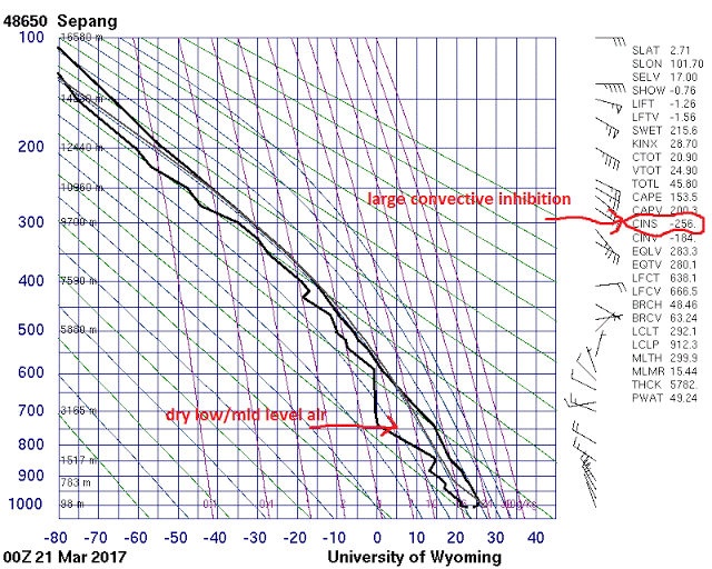
Figure 1:The Skew-T sounding this morning at around 00Z for Kuala Lumpur International Airport upper air station indicating some dry low/mid level dry air and large convective inhibition.
Figure 2:The Stuve sounding this morning at around 00Z for Kuala Lumpur International Airport upper air station indicating some dry low/mid level dry air and large convective inhibition.
Update:The forecast has been updated taking into account the latest data and the chance of rain for this afternoon has been downgraded.The downgrade took into account some dry low/mid level air and large convective inhibition for the 00Z radiosonde sounding this morning as well as the latest numerical weather prediction guidance.
During Tuesday and Wednesday northwesterly low level winds are expected over the region and a steering flow somewhat from the west due to a strengthened southern monsoon trough south of Indonesia along with the possible development of two tropical cyclone south of Java island within that monsoon trough.The Perth Tropical Cyclone Warning Center(TCWC) of the Australian Bureau of Meteorology(BOM) expects a high chance of the tropical low slightly to the northwest of Broome to develop into a tropical cyclone on Thursday with an increasing chances of the tropical low near the Cocos and Christmas Islands developing into a tropical cyclone towards the end of the week.
Medium to high chances of showers and thunderstorms are still expected then(during Tuesday and Wednesday) with the atmosphere remaining moist and unstable and the steering flow then also means a slight chance of showers and thunderstorms in the morning as showers and thunderstorms which form offshore due to land breeze convergence are steered towards the coast.
Then from Thursday the doldrums lie over the region again with light low level winds,this should also lead to a high to very high chances of showers and thunderstorms especially in the afternoon/evening but there is some uncertainty with possible dry air moving in aloft then.
The precis(summary) forecasts
and "chance of any rain forecasts" are for Kuala Lumpur City Center
while the detailed description underneath the precis forecasts is for
the forecast area of Greater Kuala Lumpur area including the Klang
Valley but the chance of rain forecasts in the detailed description
underneath the precis forecasts is the average for the forecast area
unless otherwise stated.
The weather forecasts are produced by me and not by any government agency.Use at your own risk.

